Table of Contents >> Show >> Hide
- Why the Deep Ocean Still Feels Like Outer Space (But Wetter)
- Meet the XPRIZE Winners (and Their Not-So-Imaginary Robot Crew)
- How These Machines Actually Work
- What “Unlocking Secrets” Looks Like in Practice
- From Prize Demo to Everyday Tool: What Comes Next
- Frequently Asked Questions
- Experience Add-On: What It’s Like to “Work With” Ocean Robots (500+ Words)
- Conclusion
If aliens ever visit Earth, there’s a decent chance they’ll land in the ocean and immediately feel right at home
because we still haven’t properly mapped most of it. We’ve put rovers on Mars, streamed 4K video from mountaintops,
and taught phones to unlock with our faces… yet huge stretches of the seafloor remain a giant blue question mark.
The good news: a new generation of prize-winning ocean robots is turning that question mark into an actual map.
The Shell Ocean Discovery XPRIZE pushed teams to build autonomous systems that can head offshore,
map deep seafloor fast, and send back usable data with minimal human babysitting. The resulting machinesuncrewed
surface vessels, autonomous underwater vehicles, clever sonar payloads, and software that stitches it all togetherare
more than flashy prototypes. They’re a preview of how we’ll explore the deep ocean in the coming decade: cheaper,
faster, and scalable enough to matter.
Why the Deep Ocean Still Feels Like Outer Space (But Wetter)
The map is missing where the stakes are surprisingly high
“Unmapped ocean” sounds like a trivia fact you’d hear during a documentary voiceover right before a commercial break.
But the blank spots affect real decisions. Seafloor maps help scientists understand plate tectonics and underwater
volcanoes, model ocean circulation that influences climate, plan safer routes for ships and undersea cables, and identify
habitats worth protecting. Even disaster planningthink tsunamis and underwater landslidesbenefits from better
bathymetry (the underwater equivalent of topography).
Why it’s so hard: pressure, darkness, and the “no GPS” problem
The deep sea isn’t just dark. It’s crush-your-submarine dark. At thousands of meters down, pressure is intense, water is
cold, and radio signals don’t travel far. GPS doesn’t work underwater, so vehicles must navigate using onboard sensors
and acoustics. And because visibility is limited, we rely heavily on soundespecially sonarto “see” the
seafloor. That’s why modern ocean exploration looks less like scuba diving and more like flying a robot plane through a
pitch-black canyon using sound pulses and math.
Meet the XPRIZE Winners (and Their Not-So-Imaginary Robot Crew)
The Ocean Discovery challenge didn’t reward the shiniest robot. It rewarded the team that could deliver reliable,
high-resolution mapping and imaging under strict rules, with systems that could operate with minimal human intervention.
Here’s what made the top approaches stand out.
Grand Prize: GEBCO-NF Alumni and the “mothership + diver” strategy
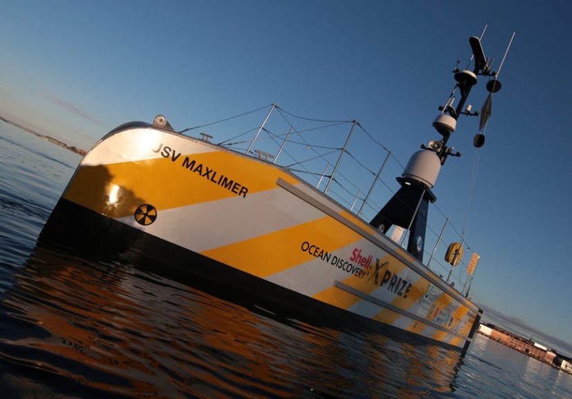
The grand-prize-winning approach from GEBCO-NF Alumni leaned into a smart division of labor:
an uncrewed surface vessel (think “robot boat”) acts as a mobile base, while one or more
autonomous underwater vehicles (AUVs) do the deep mapping.
On the surface, the robot boat can handle communications, manage mission logistics, and serve as a launch/recovery hub.
Underwater, the AUV carries sonar and cameras to capture the high-resolution bathymetry and images needed to identify
features on the seafloor. The system’s real superpower isn’t just the hardwareit’s the workflow: deploying, surveying,
collecting, and processing data quickly enough to be useful, not just impressive.
Runner-up: KUROSHIO’s modular, software-friendly platform
The runner-up team KUROSHIO earned recognition for a versatile platform and software approach designed to
work with different autonomous underwater vehicles. That matters because the ocean is not a one-size-fits-all place.
A system that can integrate multiple AUV typesdifferent depths, sensors, mission stylescan adapt to changing goals
without rebuilding everything from scratch.
Moonshot award: Team Tao’s vertical-movement concept
If most ocean-mapping systems behave like underwater lawnmowerssweeping back and forth near the bottomTeam Tao’s
concept was weirder and, frankly, kind of elegant: a system focused on vertical movement within the water column.
Instead of relying only on long horizontal runs, it explored alternate ways to efficiently gather mapping data and
characterize targets. Not every radical idea wins on the scoreboard, but it can still push the entire field forward.
The bonus twist: “sniffer” tech and student teams
The competition also highlighted another direction for ocean robots: not just mapping shapes, but tracking
signalschemical or biological hints that something interesting is happening underwater. Think oil leaks,
hydrothermal vent plumes, or other trace signatures. It’s a reminder that the ocean’s “secrets” aren’t only rocks and
ridges; they’re also invisible trails in the water that machines can learn to follow.
How These Machines Actually Work
Uncrewed surface vessels: the floating mission control
A robot boat may not sound glamorous until you realize what it replaces: a crewed ship that costs serious money per day,
plus the logistics of staffing, safety, fuel, and time. Uncrewed surface vessels can stay out longer, operate with smaller
teams onshore, and serve as a persistent “base station” in remote areas. They can also act as a communications relay
between underwater vehicles and the outside world.
AUVs: the deep-sea workhorses
An AUV is essentially a self-directed underwater aircraft. It glides through the water along a planned route, using onboard
navigation and sensors to maintain altitude above the seafloor and collect data. For mapping, AUVs often fly relatively
close to the bottom, because proximity improves resolution. Many are built with pressure-rated housings, energy-efficient
propulsion, and payload bays for sonar, cameras, and environmental sensors.
Sonar: because light gives up first
Cameras are useful for imagery, but sonar is the backbone of deep seafloor mapping. Modern mapping commonly uses
multibeam sonar, which sends out a fan of sound pulses and measures the return time to estimate depth across
a wide swath. In simple terms: one ping, many depth measurements. With enough pings, you build a detailed 3D map.
AUV mapping setups may also use sidescan sonar (great for seafloor texture and objects), sub-bottom profilers
(to peek into sediment layers), and targeted acoustic methods for specific features. The choice depends on whether you’re
mapping broad terrain, hunting objects like wrecks, or studying geology.
Navigation without GPS: the “underwater sense of direction” toolkit
Underwater navigation is a game of smart compromises. Many vehicles combine:
- Inertial navigation (keeps track of motion over time)
- Doppler velocity logs (measures speed relative to the seafloor)
- Acoustic positioning (beacons or modems for updates and correction)
- Terrain-based navigation (matching sonar observations to known features when available)
The result is a navigation solution that’s good enough to produce accurate maps, even when the environment actively
tries to confuse your sensors.
Autonomy and AI: the robots do the boring parts (and that’s the point)
Autonomy isn’t a marketing word hereit’s survival. An ocean-mapping system must handle routine decisions:
staying on course, adjusting to currents, maintaining safe altitude above rugged terrain, managing power, and deciding
what data to store or transmit first. The more those decisions can happen onboard, the less the mission depends on
constant human intervention and expensive ship time.
What “Unlocking Secrets” Looks Like in Practice
Secret #1: We can find the features that shape ocean life
The seafloor isn’t flat. It’s full of ridges, canyons, seamounts, trenches, vents, and sediment plainseach influencing
currents and habitats. High-resolution maps help scientists locate areas where life clusters, where nutrients flow, and where
geological activity creates unique ecosystems. If you’re trying to understand biodiversity in the deep ocean, you need the
physical context.
Secret #2: Better maps improve climate and hazard models
Ocean circulation is affected by underwater terrain in ways that ripple upward into climate systems. Bathymetry influences
how deep currents move heat and carbon around the planet. On the hazards side, mapping helps identify unstable slopes that
could trigger underwater landslides and, in some cases, tsunamis. Mapping also supports safer coastal planning and better
understanding of earthquake zones under the sea.
Secret #3: “Discovery” is as much about workflow as it is about sensors
A breakthrough isn’t only a better sonar. It’s an end-to-end pipeline: deploy quickly, gather data efficiently, process it
reliably, and produce outputs people can use. Prize-winning systems emphasized integrationhardware plus software plus
mission planning plus data management. That’s how the ocean becomes searchable, not just mysterious.
From Prize Demo to Everyday Tool: What Comes Next
Scaling to global mapping goals
The world is moving toward much more comprehensive seafloor mapping, and autonomous systems are one of the few realistic
ways to scale. Crew time is expensive and limited. Robot fleets can multiply coverageespecially when surface vessels can
deploy and manage multiple AUVs over extended periods.
More swarms, longer endurance, smarter data handling
Expect progress in three areas:
- Endurance: better batteries, energy management, and efficient gliding strategies
- Collaboration: multiple vehicles coordinating to map faster and cross-check data quality
- Data pipelines: faster onboard processing and cleaner handoffs to cloud workflows
The future looks less like one heroic sub and more like a well-coordinated team: surface motherships, multiple AUVs, and
software that treats the ocean as a data problem you can actually finish.
Responsible exploration matters
Better mapping can support conservation and safer navigation, but it can also inform resource exploration. The technology
itself is neutral; how it’s used is not. A major opportunity in the coming years is building standards around data sharing,
environmental safeguards, and transparent governanceso “unlocking secrets” doesn’t turn into “unlocking problems.”
Frequently Asked Questions
Are these robots replacing human oceanographers?
No. They’re replacing the most expensive and repetitive parts of oceanographic logistics. Humans still design missions,
interpret results, verify discoveries, and decide what matters. The robots do the long, steady work of collecting consistent
dataespecially in places humans can’t easily go.
Why not just use satellites to map everything?
Satellites can estimate broad seafloor features indirectly, but they can’t provide the kind of high-resolution bathymetry
produced by sonar systems in the water. For detailed, navigable maps and scientific-grade terrain models, you need
acoustic mapping from ships, robot boats, or underwater vehicles.
What’s the biggest technical bottleneck?
Reliable autonomy at scale. Underwater communication is limited, navigation is tricky, and missions can last long enough
for small errors to become big problems. Improving robustnessfault tolerance, recovery behaviors, and real-time decision
logicis just as important as new sensors.
Experience Add-On: What It’s Like to “Work With” Ocean Robots (500+ Words)
You don’t have to be a deep-sea engineer to feel the emotional whiplash of modern ocean exploration. One minute you’re
staring at a calm horizon, the next you’re trusting a robot to dive into a black, high-pressure world and come back with a
map of terrain no human has ever seen. And the weirdest part is how ordinary it can feeluntil you remember what’s
happening below.
Picture a typical autonomous mapping operation. The surface vessel looks almost underwhelming at first: a compact, utilitarian
craft that doesn’t scream “historic discovery.” It’s the ocean equivalent of a delivery van. But that’s the point. It’s designed
for stamina, not glamour. Once it’s on station, everything becomes routine and precise: check power systems, validate
communications, confirm weather windows, load mission plans, run safety checks. The tone is less “Indiana Jones” and more
“airline pilot,” because reliability is the real adventure.
Then comes the moment when the AUV is deployed. There’s a small ceremony to iteven if nobody calls it that. Teams watch
sensor feeds and status indicators like they’re reading a heartbeat monitor. The vehicle slips under the surface, and suddenly
you’re operating on faith in engineering: thrusters, seals, software, and the physics of buoyancy. When it descends, the ocean
doesn’t gradually get darker like a sunset. It becomes dark fast, then colder, then quieter in a way that’s hard to describe.
You’re not hearing the deep sea, of courseyou’re hearing your own room, your own keyboard, your own coffee cup. The robot
is the one listening, through sonar pings and acoustic replies.
The first time you see raw bathymetry data come in, it’s not a dramatic “reveal.” It’s more like watching fog lift from a
landscape in slow motion. At first the map looks blocky, like a pixelated video game level. Then the resolution improves:
ridges sharpen, slopes become legible, and features that were once rumors in coarse global models appear with real geometry.
A canyon wall starts to look like a canyon wall. A mound becomes a mound with a crest and flanks. The seafloor stops being a
theoretical surface and becomes a place.
And then you experience the second whiplash: the sheer amount of data. “Discovery” is not a single image; it’s a pipeline.
Sonar needs calibration. Navigation needs correction. Artifacts need filtering. Imagery needs quality checks. Even the best
system produces data that must be validated, stitched, and interpreted. You begin to appreciate why prize-winning teams
emphasized automation and fast processing: the bottleneck isn’t only the oceanit’s the human capacity to handle what the
ocean hands back.
The most satisfying moment isn’t when the robot dives. It’s when it returns and the story holds together: mission completed,
tracklines make sense, the map is coherent, the feature list checks out. That’s when the humor kicks in, too. Teams joke about
“robot drama” when a sensor throws a warning, or about “underwater GPS” being a fantasy we all wish existed. But under the
jokes is real respect. The ocean doesn’t care about your deadlines, your funding cycles, or your conference schedule. If a robot
can repeatedly map deep seafloor accurately, that’s not just technologyit’s a new relationship with a planet we barely know.
Conclusion
The Shell Ocean Discovery XPRIZE didn’t just name winners; it spotlighted a practical blueprint for exploring the deep ocean
at scale. The winning machines combine uncrewed surface vessels, autonomous underwater vehicles, modern sonar, and smart
data workflows to do something humanity has historically struggled with: map the seafloor quickly, affordably, and reliably.
As these systems mature, the ocean’s “deepest secrets” won’t remain secrets because of luck or heroicsthey’ll become
discoverable because the tools finally match the size of the challenge.